Mapping Borders
Modern maps of the ancient world use modern concepts of statehood and borders that did not exist at the time. The Treaty of Westphalia in 1648 ending the 30 Years War is seen as the inflection point in how people conceived of states, and consequently how they represented them on maps.
Overview
A perennial challenge for all modern map makers is that modern audiences expect a map with post-Westphalian borders, where the political entity’s extent of control is delineated by a clear border and control within that border is complete and uniform, with no overlapping claims.
What do pre- and post-Westphalian maps look like and how did people think about borders? How could that influence modern maps of the ancient world? How does Running Reality approach creating a dynamic digital map that balances historical accuracy and modern expectations?
Treaty of Westphalia
The concept of Westphalian statehood emerged from the Peace of Westphalia in 1648, which ended the Thirty Years’ War in the Holy Roman Empire and the Eighty Years’ War between Spain and the Dutch Republic. This series of treaties is often cited as the foundational moment for the modern international system of sovereign states.
Europe in the early 17th century was fragmented by religious and territorial conflicts, especially between Catholic and Protestant powers. This particular treaty was very influential across such diverse European powers because these wars involved so many of them and therefore the Peace of Westphalia was signed by the Holy Roman Empire, France, Sweden, Spain, and the Dutch Republic, among others.
The Treaty established the principle of non-intervention in the domestic affairs of other states. Further, it was an affirmation of the legal equality of states, regardless of size or power. While these concepts did not originate in the Treaty, it was the first codification of these principles between a large number of states.
Notions of Statehood
The Westphalian model laid the groundwork for the modern system of nation-states, where territorial sovereignty, legal equality, and non-interference became the guiding principles. It represented a major shift from medieval concepts of power to a more modern idea of the state as a legal-political institution, paving the way for concepts like citizenship, nationalism, and international law.
While the Peace of Westphalia primarily concerned state sovereignty, it also had long-term implications for national identity. Prior to Westphalia, people owed allegiance to a person (the monarch, lord, or pope). After Westphalia, allegiance increasingly shifted to a political entity, the state, which existed independent of any single ruler. The idea of citizenship—membership in a state rather than loyalty to a monarch—gradually developed. This was the start of a slow process that still took additional centuries to take its modern form.
Before Westphalia, the dominant political idea was monarchical sovereignty based on divine right and feudal structures. The state was often seen as personal property of the monarch (e.g., the phrase "L'état, c'est moi"—"I am the state"—attributed to Louis XIV). Land was held by nobles in a hierarchy of vassalage, all ultimately tied to the monarch’s ownership. People were subjects of the king, not citizens of a state. Their identity and rights were defined by their status in the feudal order, not by membership in a political community. Territories had unclear boundaries, and different authorities (secular and religious) could claim overlapping powers.
| Aspect | Pre-Westphalian | Post-Westphalian |
|---|---|---|
| Sovereignty | Feudal and personal to the monarch | Resides in the impersonal state |
| Political Authority | Based on divine right and feudal ties | Based on territorial integrity and law |
| National Identity | Loyalty to ruler | Loyalty to the state (early national identity) |
| Borders | Fluid and overlapping | Defined and respected by other states |
Control of Territory
Ancient imperial systems were built on networks of allegiance, not lines on a map. Control was dynamic, contingent, and relational, not legal and territorial. Borders were not physical frontiers but moving frontlines, defined by who paid tribute, who feared reprisal, and who marched where. The presence of an army was often the most concrete border there was.
In the medieval and early modern periods, political authority was not centralized or neatly confined within geographic borders. Instead, multiple entities could simultaneously claim and exercise jurisdiction over the same territory or people, often based on different kinds of authority: religious, feudal, dynastic, or imperial.
Some examples of overlapping jurisdiction are:
- The Catholic Church had vast landholdings, courts, and legal authority across Europe. In many regions, church law (canon law) operated alongside or even above secular law.
- Monarchs often ruled over composite monarchies—territories that had separate laws and institutions. The King of England was also Duke of Normandy (a vassal of the French King) and such overlapping claims contributed to conflicts like the Hundred Years' War
- Vassals might owe military or legal duties to more than one overlord, especially through marriage or inheritance. A nobleman might have estates in both France and the Holy Roman Empire
Overlapping borders in pre-Westphalian Europe reflected a world where power was shared, contested, and personal. The shift to Westphalian sovereignty introduced the revolutionary idea that a state should have singular and supreme authority over its own land, laws, and people—a cornerstone of modern geopolitics.
Historical Examples
In ancient systems of empire and sovereignty, borders were fundamentally fluid and functional, not geographic in the modern sense. Control was about which cities or regions paid tribute or recognized authority, not about fixed lines on a map. We look at three examples: The Holy Roman Empire, Macedon under Alexander the Great, and the Aztec Empire.
The Holy Roman Empire was a loose confederation of hundreds of principalities, duchies, bishoprics, and free cities. A local prince might owe fealty to the Emperor but also be subject to the Pope in religious matters. Citizens could be under the legal jurisdiction of several lords, depending on the nature of a dispute—civil, religious, or military.
After Alexander defeated Darius III at Gaugamela, the territory of the Persian Empire didn’t simply become the territory of Macedon in the modern sense. Instead, cities and satraps (provincial governors) either submitted to Alexander, or resisted and were conquered. Each city or region made a pragmatic decision based on whether Alexander’s army was nearby and whether he appeared to be sufficiently legitimate. Many cities switched allegiance after Gaugamela not because of a treaty or border shift, but because the symbolic and military center of power had moved. The “border” of Alexander’s empire was effectively the outer edge of where his army had passed through, and it only stabilized when his successors held it with garrisons.
The Aztec Empire (or Triple Alliance) operated a tributary empire, not a territorially integrated state. It was composed of many semi-autonomous city-states (altepetl) that paid tribute to the Aztec capital, Tenochtitlan. The empire didn’t impose uniform administration—loyalty was extracted through tribute, fear, and ritual. The Tlatoani (emperor) had to physically visit rebellious or distant regions with his army to reaffirm dominance. Tribute often resumed after an imperial visit, show of force, or suppression of a revolt. No fixed border existed between Aztec and non-Aztec territory. Instead, what marked the edge of the empire was the last city that still paid tribute or was recently subjugated.
Ancient imperial systems were built on networks of allegiance, not lines on a map. Control was dynamic, contingent, and relational, not legal and territorial. Borders were not physical frontiers but moving frontlines, defined by who paid tribute, who feared reprisal, and who marched where. The presence of an army was often the most concrete border there was.
Evolution of Mapping
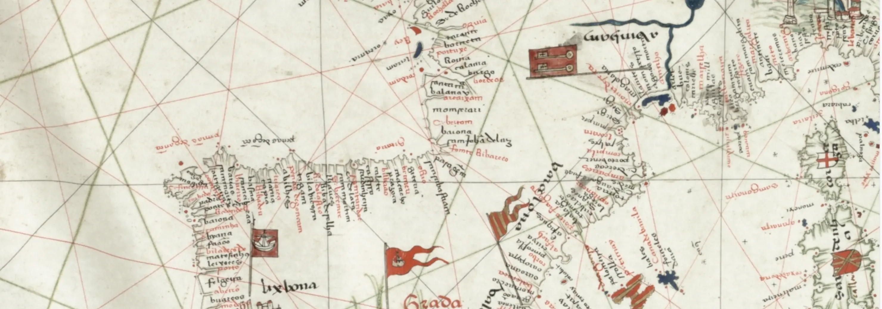
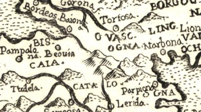
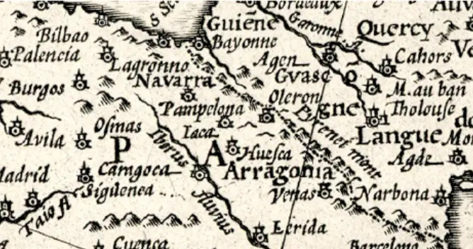
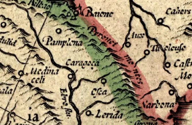
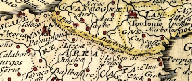
How did maps change at this time? How did they look beforehand? Pickering (2013) analyzed a large set of historical maps of Europe before and after the Treaty of Westphalia and documented the rapid change in how nations and their borders are represented. His paper, "Borderlines: Maps and the spread of the Westphalian state from Europe to Asia Part One – The European Context" (November 2013 The International Archives of the Photogrammetry Remote Sensing and Spatial Information Sciences XL-4/W3(4):111-116) (DOI:10.5194/isprsarchives-XL-4-W3-111-2013) shows how maps in the 1500s rarely, if ever, showed national borders but then by the late 1600s most European maps were showing borders. Four such maps are excerpted here, and the full paper is available below.
Modern Mapping
Modern maps of the ancient world must balance properly representing the political reality of the ancient world and being understood by the modern audience reading the maps. Any attempt to draw distinct borders has some inherent uncertainty, and this is magnified by digital maps that can zoom in to meter-level features. However, the modern audience has seen innumerable historical maps with post-Westphalian borders of the Roman Empire and expects their digital maps to do the same. Maps with visually clean borders are considered more credible than those overlapping borders or "sketched" borders.
Running Reality studied a range of approaches and alternatives to a post-Westphalian border approach. To be viable, alternatives must have both a clear, understandable visualization and sufficiently better underlying data. Doing a more city-state or ambiguous-extent-of-control model, might be conceptually more accurate but there might not be sufficient or sufficiently accurate data.
| Border Model: | Post-Westphalian | Ambiguous Border | City-State | Vassalage |
|---|---|---|---|---|
| Description | A state is delineated by its border, with uniform sovereignty within that border. | A state is delineated by a blurred border to indicate sovereignty might not be as high at the edge. | A state's territory is the sum of the territories of the cities having allegiance | A state's territory is the sum of the territories controlled by individual lords having allegiance |
| Visualization | Traditional GIS-style polygon | A polygon, but with high blur | A geometric union of circles around cities | A geometric union of polygons of lords |
| Data Requirements | Prior, well-researched modern maps of the ancient world | Prior maps plus uncertainty data to set the degree of blur | Data on city-level control, by year, which is uneven | Data for the levels of feudal hierarchies |
| Temporal Changes | Requires a full polygon update, even for unchanged territory | Requires a full polygon update, even for unchanged territory | Adjusts when a city is documented to join or depart | Adjusts when a vassal is documented to join or depart |
Ideally, we’d have a truly pre-Westphalian approach where you’d say only “I have research that shows these 4 cities paid tribute to this king in 300AD,” or only “this additional land was conquered in 300AD." In practice, such an influence-based or event-based border model would be too complex for people entering data, which would lead to fewer contributions and more mistakes. It is not clear that there would be a net benefit in model accuracy.
Another consideration for high-resolution maps is to incorporate terrain. Running Reality has a base map that shows mountain ranges and passes in detail and shows changing river courses and shorelines. While it is not necessarily strictly documented in the historical record, when drawing a "fuzzy" line between states using a precise polygon, the track of the polygon can be aligned to the terrain. This approach is not fully accurate, but is plausibly at least as accurate as any other polygon track.
Running Reality recently updated its map of the Aztec Empire. We used a hybrid approach where we used a post-Westphalian border to delineate the territory considered to be "in" the Empire, but with border changes tied directly to the movements of the army into territories. As the army approached another city, and it became "part of the empire" through vassalage or tribute or alliance, we updated the border. We encompassed the city-state's territory in the new Aztec border polygon, generally defining the city-state's territory as the territory in that valley up to a mountain ridge, a river, or a pass.
| Border Model: | Hybrid |
|---|---|
| Description | A state is delineated by its border, with uniform sovereignty within that border. |
| Visualization | Traditional GIS-style polygon |
| Data Requirements | Well-researched modern maps, city-state based allegiance, with terrain inferences |
| Temporal Changes | Incorporates event-based changes, such as battles |
Running Reality also defines territories populated by a group of people of coherent identity but without a state-level political hierarchy as Cultural Groups, or a sub-type thereof. We use the same visualization and data approach as for states, though an argument could be made to take an "Ambiguous Border" approach and to allow more overlaps. While that might be more theoretically accurate, data for the territories of such groups is already imprecise, so an elevated data requirement might not actually result in a more accurate model.
Summary
Modern maps of the ancient world use modern concepts of statehood and borders that did not exist at the time. The Treaty of Westphalia in 1648 ending the 30 Years War is seen as the inflection point in how people conceived of states, and consequently how they represented them on maps. Modern audiences expect a map with post-Westphalian borders, where the political entity’s extent of control is delineated by a clear border and control within that border is complete and uniform, with no overlapping claims. Running Reality attempts to balance these ideas in its world history model.